 ....
........
.....
.....
Appendix D.
Changes
.....
Changes in the Map of Europe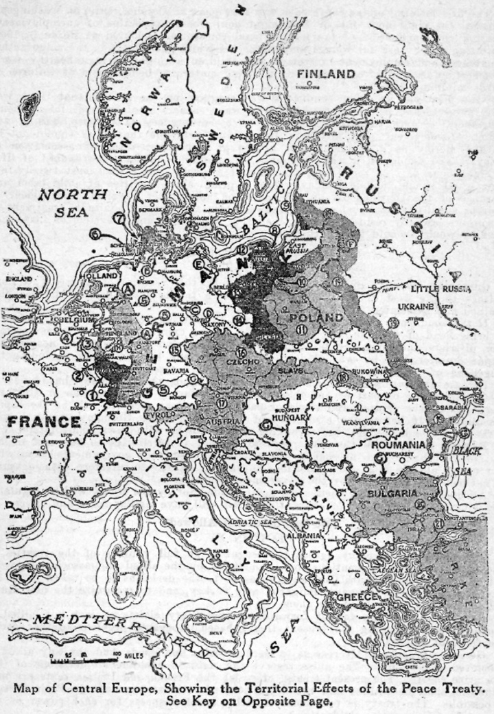
The changes made in the map of Central Europe by the terms of the Treaty of Peace handed to the German peace delegates at Versailles on May 7, 1919, are shown on the map. The principal issue, in a territorial or geographic sense, are (See corresponding figures and letters in the map):
1. Alsace-Lorraine, the territories which were wrenched from France in 1871, are restored to the republic. The French in the lost provinces now regained are repatriated, and the Germans there may become French citizens, if they so desire, by naturalization after three years. The public debt is cancelled.
2. The Saar valley will pass into the hands of the French, together with the output of the mines. After fifteen years the people of the district will vote whether they shall remain under French control, under the guidance of the league of nations, or return to Germany. This voting will be open to all inhabitants over 20 years of age.
3. Germany must renounce all treaties with Luxembourg and must give up the German control of the railways and other facilities in the grand duchy. The duchy is considered to have ceased to have been part of the German Zollverein from Jan. 1, 1919.
4. Germany must recognize the sovereignty of Belgium over the contested territory of Morenet, and must cede all rights to the districts of Malmedy and Eupen. The people in six months may protest, if they wish to, this change. The districts affected comprise 382 square miles.
5. Germany must create a neutral zone thirty miles in depth east of the Rhine. The bridgeheads will be occupied fifteen years.
6. Helgoland, the island fortress, is to be dismantled at German expense and by German labor.
7. The frontier between Germany and Denmark will be decided by a plebiscite. The people of Schleswig-Holstein will decide under the right of self-determination.
8. Danzig and the immediate vicinity will be a free port, giving Poland an outlet to the sea. It will be protected by the league of nations.
9. The territory around Memel must be given up to the allies, who will decide on its destination.
10. The boundaries of southern and eastern Prussia will be decided by a vote of the people. The German troops must move out within fifteen days after peace is signed.
11. Germany must recognize the independence of the new Poland.
12. The portion of West Prussia on the left bank of the Vistula must be ceded to Poland,
13. Posen must be ceded to Poland,
14. The greater part of Upper Silesia is to go to Poland.
15. The present border between Germany and Bohemia is to remain unchanged.
16. Germany must recognize the independence of the new nation of Czecho-Slovakia. Access to the sea must be provided by railroads to the Adriatic at Fiume and Triest, and in the north Germany must lease space in Hamburg and Stettin.
17. Germany must recognize the independence of German Austria.
18. The Ruthenians in Hungary are to be recognized as independent.
19. The entire Russian boundary must be restored to the lines of the old Russian empire. The treaties of Brest-Litovsk and other treaties with the Russian soviet government are abrogated.
20. Germany must accept any arrangement the allies make with Bulgaria.
21. The Germans must accept any arrangement the allies make with Turkey.
The rivers running through the old Germany and Austria-Hungary are to be internationalized and largely controlled by representatives of the allies:
A. The Rhine will be internationalized on the whole of its navigable course.
B. The Kiel canal, base of the German fleet, is to be opened to the ships of the world.
C. The Elbe river from the juncture of the Vltava to its mouth is to be internationalized.
D. The Vltava as far up as Prague is to be internationalized, giving the city an outlet to the sea.
E. The internationalization of the Oder will be between Oppa and the. mouth of the stream.
F. The Niemen river must be opened to the vessels of the world as far up as Grodno.
G. The entire course of the Danube from Ulm to the Black sea is internationalized.
H. The Moselle river is placed under the same international river control commission as the Rhine.
The changes in the treaty of peace agreed upon by the Allies and promulgated June 16, 1919, when the revised treaty was handed to the Germans, included the following:
1. A plebiscite for Upper Silesia, with guarantees of coal from that territory.
2. Frontier rectifications In West Prussia.
3. Omission of the third zone In the Schleswig plebiscite.
4. Temporary increase of the German army from 100,000 to 200,000 men,
5. Declaration of the Intention to submit within a month of signature a list of those accused of violation of the laws and customs of war.
6. Offer to co-operate with a German commission on reparations, and to receive suggestions for discharging the obligation.
7. Certain detailed modifications in the finance, economic, and ports and waterways clauses, including abolition of the proposed Kiel canal commission.
8. Assurance of membership In the League of Nations in the early future, if Germany fulfills her obligations.
After the German national assembly at Weimar had voted in favor of signing the treaty of peace, Sunday, June 22, 1919, and the Scheidemann government had been replaced by a cabinet headed by Herr Bauer, a new set of plenipotentiaries was named to sign on behalf of Germany, and the treaty was finally signed by the representatives of the Allied powers and Germany, at Versailles, Saturday, June 28, 1919.
The Germans delegated by the Bauer government to sign the treaty were: Dr. Herman Mueller, foreign minister; Dr. Bell, minister of colonies; Herr Leinert, and Herr Giesberts. With their signatures came the conclusion of peace---the official end of the great World War.